|
Sulgrave is a
small village to the north west of Silverstone which you reach from
a turning off the A43 near Syresham between Silverstone and Brackley.
From Silverstone the route is around 9.5 miles and takes around
15 to 20 minutes. V8 Register members attend an informal supper
at the Star Inn in Sulgrave on the Friday evening of the International
MG Meeting of the MG Car Club.
Getting
to Silverstone Circuit
From the north and west you can reach Silverstone on the A43 from
the M40 at J10. From the north and east you can approach Silverstone
on the A43 from the A5 at Towcester and the M1 at J15a. From the south
you can use either the M1 or the M40 or alternatively you can follow
a very pleasant rural route from Aylesbury via Winslow, Buckingham
and Stowe and then the small village of Dadford just south of the
Circuit.
Please note - the map above incorrectly marks the M40 (on
the LHS)
as the M4. It is the M40!
Route
from Silverstone Circuit to Sulgrave village
The Star Inn at Sulgrave, a small village to the north west
of the A43 between Silverstone and Brackley, is around 9.5 miles
from Silverstone. The map below shows the winding route through
the country lanes to Sulgrave. Leave the Circuit and turn right
onto the short section of road that takes you to the underpass on
the new section of dual carriageway bypass for Silverstone village.
Turn left down the slip road and head south west along the A43.
After just under three and half miles after passing by Syresham,
turn right off the A43 on to a minor road signposted for Sulgrave.
Note, with the new dual carriageway, this entails a short double-back
along the north eastern carriageway of the A43 to the turning for
Crowfield. The route to Sulgrave is then on minor roads where
you will need to follow the map below carefully and look out for
the signposts for Helmdon and then Sulgrave.
Beware of speed
cameras on this route!
Northamptonshire is littered with speed cameras, many of which
appear to be sited more for revenue generation than based on analyses
of accident statistics. Please note there are two speed cameras
on this route:
On the A43,
just a mile and half from Silverstone there is a speed camera
on a section of dual carriageway before Syresham as you head west
towards Brackley. The camera is sited on a downhill slope with a
mile of dual carriageway ahead where it passes the popular Green
Man pub on the other side of the road. Most V8 enthusiasts would
be tempted to open up the throttle on seeing a section of dual carriageway
ahead, and with a downhill slope it is very easy for your speed
to rise rapidly - beware this speed camera is sitting there
on the LHS at the start of the dual carriageway to catch you!
Half
a mile after turning off the A43 onto a straight section of
minor road you will find another speed camera in the hamlet called
Crowfield. As you come into Crowfield there is an "S"
bend (right, then left) which drops through a hollow and then continues
as a very tempting straight section of road past a chicken farm.
Take care - there is a speed camera on the exit of the "S"
bend just as you leave the hamlet. When returning from Sulgrave
on this route, you will of course need to remember this camera is
on the approach to Crowfield at the end of that long straight section
of relatively smooth road.
These speed
cameras are marked on the detailed route map available by clicking
the link below.
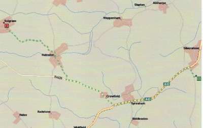
Route from Silverstone Circuit to the small village of Sulgrave.
For a larger,
more detailed route map from Silverstone Circuit to Sulgrave,
see Sulgrave route. If you then
print that map online you will probably only get the lefthand third
of the map! To print a full copy of this large scale map you have
two options:
1. You will need to save the image you can see online to your
PC, probably to My Documents, using the small Save icon that
appears when you run your mouse over the image. You then insert
it into a new document in Word paginated for landscape format. Then
print the Word document and you should have the whole map!
OR
2. You can download the map already inserted into a Word document
in landscape format - just click Sulgrave
route map. The file size is around 55kb so may take 12 to 15
seconds to download, depending on your internet connection speed.
Victor Smith
|